• UGIC 2016 GIS Day at Escalante High School
  • Maps on the Hill 2015
  • Doug telling people about drones, Earth Observation Day 2015

The Remote Sensing/Geographic Information Systems (RS/GIS) Laboratory is a geospatial analysis and mapping facility in the Quinney College of Natural Resources at Utah State University. The lab is funded by grants and contacts provided by federal and state agencies, county and city governments, private and nongovernmental organizations, and other academic institutions. The RS/GIS Laboratory employs professional staff, graduate students, and undergraduate student technicians to conduct applied research and to work on a variety of geospatial- and natural resource-related projects.

The RS/GIS Laboratory is located in the Janet Quinney Lawson Building on the Utah State University campus in Logan, Utah. The RS/GIS Laboratory provides an environment where faculty, professional staff, graduate students, and undergraduate student technicians work in cooperation to:

  • INTEGRATE remote sensing, geographic information systems, and global positioning technologies with on-the-ground knowledge to address natural resource and environmental issues.
  • CONDUCT applied research that focuses on critical natural resource and environmental issues, such as invasive species; natural and anthropogenic disturbances; carbon cycling and management; endangered, threatened, and sensitive species; and water quality and management.
  • ADVANCE the knowledge of geospatial technologies through the development of innovative processes.
  • TRANSFER knowledge and skills to students, the local community, federal and state agencies, land managers, policy makers, and stakeholders through education, outreach, and training.
  • PROMOTE the distribution and use of geospatial data and information.

Earth Observation Day Event

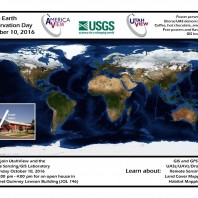
Please join UtahView and the Remote Sensing/GIS Laboratory in celebrating Earth Observation Day on Monday October 10, 2016 from 2:00 pm to 4:00 pm for an open house in the Janet Quinney Lawson Building (JQL Room 146). Come learn about GIS, GPS, remote sensing, UASs/drones, land cover mapping, and habitat mapping. There will be drinks and snacks, free posters, and a GIS book raffle.

Recent blog posts

Last year I created some interactive control flow examples for the Python class I teach. In preparation for this year, I cleaned them up a bit and published them at https://usu-python.gitlab.io/control-flow/. I hope they’re useful for someone!

Today someone asked me for help with exporting data from ArcGIS to a csv file, but with different column names. He had found solutions online that involved exporting to Excel, changing the column names there, and then exporting to a csv, but there’s a much simpler way to do it. In fact, here’s a function …